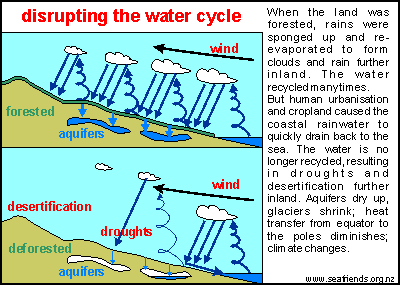
Trees provide low temperatures that are needed to help the clouds to form precipitation. This precipitated rain is then drained into the ground and released as rivers towards the lower areas , in this case,Athi River flow towards Galana Malindi , Indian Ocean.
[googlemaps https://www.google.com/maps/embed?pb=!1m18!1m12!1m3!1d130954.10678162526!2d39.98991327874543!3d-3.1403916073002733!2m3!1f0!2f0!3f0!3m2!1i1024!2i768!4f13.1!3m3!1m2!1s0x0%3A0x0!2zM8KwMDknNTIuMSJTIDQwwrAwOCcxNy45IkU!5e1!3m2!1sen!2ske!4v1568728112537!5m2!1sen!2ske&w=600&h=450]
Tree canopy shields the sun , creating a shadow that reduces the area temperatures , enabling the condensation process that creates the rain in the clouds.
Clothes line effect.
Trees absorb alot of water below ground and release it into the atmosphere, making the clouds heavier hence creating rainfall. When clothes are laid out to dry in the sun flat on the ground, they take longer to dry compared to when hung on a line above ground. This is the same effect that trees have on absorbing and releasing below ground water into the atmosphere.
Water Cycle.
This phenomenon creates a water cycle that takes up atmosheric moisture in winds from the Indian ocean which get trapped by the Ngong hills then the Ngong forest cover creates the enabling environment to make the clouds heavy, resulting into rain. This rain then flows in two tributaries to form the Athi river.
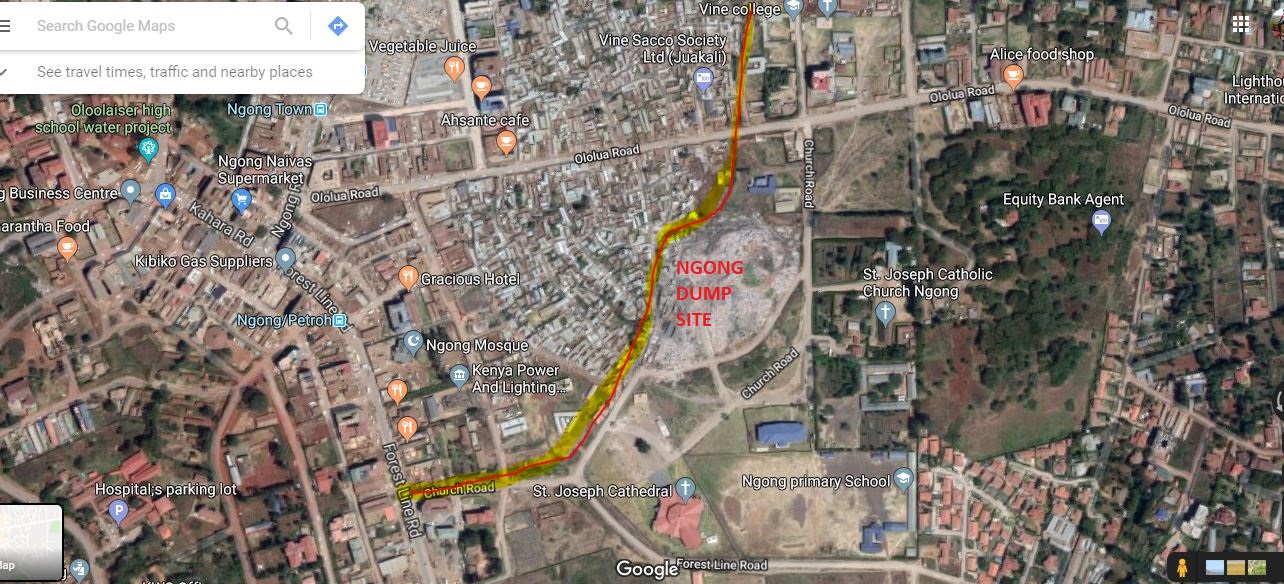
One tributary comes from Ngong hills just above Ngong town and flows through the Ngong Dumpsite towards Karen and Rongai as Kandisi River through Nairobi National Park.
[googlemaps https://www.google.com/maps/embed?pb=!1m18!1m12!1m3!1d3157.6759347039338!2d36.7188333139966!3d-1.3905139989858604!2m3!1f0!2f0!3f0!3m2!1i1024!2i768!4f13.1!3m3!1m2!1s0x0%3A0x0!2zMcKwMjMnMjUuOSJTIDM2wrA0MycxNS43IkU!5e1!3m2!1sen!2ske!4v1568727126448!5m2!1sen!2ske&w=600&h=450]
Ngong Dumpsite contaminating Athi River tributary.
The red line in the image below indicates the river source flowing on the edge of Ngong dumpsite, carrying lots of toxic chemicals all through until Malindi, Indian Ocean.
[googlemaps https://www.google.com/maps/embed?pb=!1m18!1m12!1m3!1d3073.1645160220987!2d36.65726791684897!3d-1.3623029990589135!2m3!1f0!2f0!3f0!3m2!1i1024!2i768!4f13.1!3m3!1m2!1s0x0%3A0x0!2zMcKwMjEnNDQuMyJTIDM2wrAzOSczMy44IkU!5e1!3m2!1sen!2ske!4v1568726529957!5m2!1sen!2ske&w=600&h=450]
The other tributary originates from Ngong forest area in the parts above Karinde[karen end] area just before Thogoto.
This flows as Mbagathi river towards Nairobi National Park.
[googlemaps https://www.google.com/maps/embed?pb=!1m18!1m12!1m3!1d21803.726256487542!2d36.684770931534!3d-1.3236007145316737!2m3!1f0!2f0!3f0!3m2!1i1024!2i768!4f13.1!3m3!1m2!1s0x0%3A0x0!2zMcKwMTknMzIuMyJTIDM2wrA0MSczNS4wIkU!5e1!3m2!1sen!2ske!4v1568726942498!5m2!1sen!2ske&w=600&h=450]
It passes below Former Minister Kirwa’s residence near KEPHIS and joins the other tributary in the Oloolua nature trail area to flow towards Girraffe Centre and IUCN area into Nairobi National Park. From here it becomes the main Athi River and flows all the way to Galana in Malindi into the Indian Ocean.
[googlemaps https://www.google.com/maps/embed?pb=!1m18!1m12!1m3!1d16087.73565861692!2d36.65984643876811!3d-1.3062226392358685!2m3!1f0!2f0!3f0!3m2!1i1024!2i768!4f13.1!3m3!1m2!1s0x0%3A0x0!2zMcKwMTgnMjEuNyJTIDM2wrAzOSc0NS4zIkU!5e1!3m2!1sen!2ske!4v1568726622574!5m2!1sen!2ske&w=600&h=450]
Forest encroachment.
From the map below, its clear how the Ngong forest has been encroached and trees cut to provide space for farming.
[googlemaps https://www.google.com/maps/embed?pb=!1m18!1m12!1m3!1d30002.31655118939!2d36.65204042403673!3d-1.299066990082547!2m3!1f0!2f0!3f0!3m2!1i1024!2i768!4f13.1!3m3!1m2!1s0x0%3A0x0!2zMcKwMTcnNDMuMCJTIDM2wrAzOSc1OC40IkU!5e1!3m2!1sen!2ske!4v1568727285046!5m2!1sen!2ske&w=600&h=450]
This cutting of trees has resulted in low ability of the Ngong forest to create rainfall and rivers, hence the country suffering the worst drought in 38 years as we speak.
https://www.nation.co.ke/news/Kenya-faces-worst-drought-in-38-years/1056-5077306-k2dc4z/index.html
Oloolua forest has also been encroached on the edges as shown in the map below
[googlemaps https://www.google.com/maps/embed?pb=!1m18!1m12!1m3!1d33745.27845246313!2d36.67009994618705!3d-1.3718299056761087!2m3!1f0!2f0!3f0!3m2!1i1024!2i768!4f13.1!3m3!1m2!1s0x182f049bc310dff7%3A0x80adb49515b65f1d!2sOloolua%20Forest!5e1!3m2!1sen!2ske!4v1568727484444!5m2!1sen!2ske&w=600&h=450]
Ngong hills forest cover is also dwindling as shown below
[googlemaps https://www.google.com/maps/embed?pb=!1m18!1m12!1m3!1d7126.8822570450475!2d36.63889395890572!3d-1.390094585180155!2m3!1f0!2f0!3f0!3m2!1i1024!2i768!4f13.1!3m3!1m2!1s0x182f0246874fb08b%3A0x6613fe7ccdd0fac0!2sKompass%20Restaurant!5e1!3m2!1sen!2ske!4v1568727585529!5m2!1sen!2ske&w=600&h=450]
With the reduction of forest cover, the amount of rain generated has also reduced with the same rate , causing drought, which in turn causes inflation within the country.
Kerarapon,Karen and Matasia residential areas.
Kerarapon,Karen and Matasia areas have increased the tree numbers from the dry grass land that the area was 50 years ago. This shows that with proper land management, residential areas can coexist with forests if the residents are sensitized to maintain a sizeable percentage of trees within their land .
Sensitization.
More sensitization on the need for trees and why plot owners need to each plant more trees within their lands is needed so as to increase the rain and thereby increase the volume of water in Athi river.
Architect Francis Gichuhi kamau
info@a4architect.com
0721410684