Month: December 2013

  • New Railway lines around Nairobi.

    Kenya railways has proposed new railway services from Kiserian to Ngong to Nairobi, and Ruai to Nairobi. Also, From Kikuyu to Nairobi.

    These will reduce the traffic jam on roads leading to the city.

    Effect on land price.

    Land prices around Nairobi are excessively high due to high demand since there is little or no infrastructure after the 30km radius of Nairobi CBD.

    If Kenya Railways can come up with railway transport to serve at least a 60 to 70km radius of Nairobi eg Naivasha, Kajiado etc, this will result in land prices easing and hence affordable to many Kenyans.

    Francis Gichuhi Kamau, Architect.

  • Pyramids of Giza Architecture. Nubian Domes inspiration.


    These were constructed 3000 years ago by Black Africans who originally inhabited Africa.

    By this time, Arabs and Europeans had not began to travel and colonise Africa.
    black pharaohs


    A DNA study carried out on Pharaoh Ramses shows that his DNA is similar to that found in Sub Saharan Africa as shown in the map below.

    http://www.bmj.com/content/345/bmj.e8268

    Here is a link to google maps where the actual location of the Pyramids of Giza as they are currently can be viewed.

    https://maps.google.co.ke/maps?q=pyramids+of+giza&ll=29.978264,31.133001&spn=0.011301,0.021136&hq=pyramids+of+giza&radius=15000&t=h&z=16

    https://maps.google.co.ke/maps?q=pyramids+of+giza&ll=29.978264,31.133001&spn=0.011301,0.021136&hq=pyramids+of+giza&radius=15000&t=h&z=16

    Interior of the Pyramids.

    There is a grand gallery as shown in the below picture.

    The Pyramid of Khufu was designed by an architect called Hemiunu, who was a cousin of Pharaoh Khufu.
    http://en.wikipedia.org/wiki/Hemiunu

    The pyramid is 480 ft high and sits on 13 acres of land.

    The internal ramps were used to transport the stones upwards and the shadoof like levers were used to place the stones on top of each other.

    Nubia.

    The Pharaoh rul;e extended into Nubia.

    The picture below, of a building in Nubia, shows creative use of stone beams to support the building.

    Architect Hassan Fathy and the Nubian Vault.

    Reknown Egyptian Architect Hassan Fathy extensively studied the Nubian architecture on the Nubian Vault.
    This is a vaulted curve as seen when a loose chain is held on both ends to form a curve.

    The Nubian architecture is quite impressive and very low cost compared to the Kenyan construction methods.

    It is believed that the Nubian Vault shape inspired the Pharaohs to the pyramid shape.

    Curvilinear vs Square.

    Nature builds in curvilinear forms. The Great Zimbabwe city was curvilinear in form compared to the pyramids wich were square/rectilinear.
    Curvilinear forms are very strong eg the egg, the rib cage etc.

    In my prefabricated builidns design reserch, i have found out that to come up with a dome house that accomodates the human form without wasting space as the Nubian dome does, requires alot of time in trying out various permutations and combinations.
    This means by the time the Nubians were settling on the dome, they must have had many series of trial and error. Luckily for me, use of CAD Computer Aided Design has simplified this into a shorter time period.

    The Nubian domes had sophisticated ventilations that could turn humid air into water .

    With such sophisticated construction methods, it was then easy to work on the pyramids.

    Francis Gichuhi Kamau, Architect.
    info@a4architect.com

  • Railway Station Architecture.

    Kenya recently broke ground for construction of a new railway line from Mombasa to Uganda and Rwanda.

    This will call for design of useful railway stations that are in line with international trends.
    Kenyan solutions and designs will need to be innovative and original so as to serve the people well.

    Below are a few aspects that will need to be looked at regarding design.
    1.Security
    2. Concept
    3.Economic aspect
    4. Functionality.

    1. Security.

    In the wake of terrorism, aspects that prevent terrorist attacks such as were recently witnessed at Westgate mall can be prevented using design. Crime prevention aspects can be incorporated to ensure terrorists are discouraged from staging their acts. See more info here

    http://www.a4architect.com/2013/09/25/terrorism-in-malls-how-to-use-architecture-to-prevent-attacks/

    http://www.a4architect.com/2013/09/25/terrorism-in-malls-how-to-use-architecture-to-prevent-attacks/

    2. Concept.
    A concept that is original and conveys meaning to Kenyans need to be conceived. Since this is the Jubilee year, a concept that denotes this plus enables Kenya to be united as one can be very useful. A concept that symbolises African/Kenyan achievements, ideals and pride can be conceived. The Big 5, Lion, Giraffe, Buffalo, Rhino and Leopard can be included in the design. Other natural features such as Lake Nakuru, Indian ocean, Lake Victoria, Lake Turkana, Mt Kenya, Athi and Tana river can also be included.

    3.Economic aspect.

    The large number of people attracted to the railway station will be a good location for creation of a shopping mall. Large supermarkets, franchises uch as Bata, Banks, Hospitals and other commercial activities can be included in the railway station. This will serve the railway commuters and will also generate revenue to the Government.

    Three to four storey level shopping mall set up can be designed for the railway station lobby area.

    4. Functionality.

    The railway functions should be well included in the design. The design should be such that people will not need sigh boards to heard them to the right directions.
    Toilet facilities that can be able to serve all should be in place.

    Seats should be designed such that they are uncomfortable for horizontal sleep so as to discourage vagabonds who might want to use the area as a home.

    The ticket area should be easily noticeable and should be able to separate non ticket holders so that paid up travellers can be able to access the train easily.

    The access level from the train to the lobby should be well raised/leveled to prevent accidental slips.

    Francis Gichuhi Kamau, Architect
    info@a4architect.com

  • Ingombe Ilede City, Zambia. 7th to 11thc Century AD

    http://zambianeye.com/archives/11556

    By Chimuka Moono Hanyama

    Zambian history is littered with a lot of literature on different national heritage sites. Some of these include Isamu Pati in Kalomo, Ingombe Ilede in Gwembe valley, and Broken Hillman in Kabwe.

    Ingombe Ilede is a historical site which was discovered in 1964 by government workers who were constructing a water tank in the area for the resettled Tonga people of Gwembe valley.

    It is located some kilometers away from the confluence of Kafue and Zambezi rivers.This site basically had a big Baobab tree which was positioned like a ‘sleeping cow’, hence the name. Ingombe Ilede has a rich history about slave trade.

    The site is said to be an area where slave trade and barter system used to take place. Artifacts that were collected from the area included copper crosses and beads.

    Ingombe Ilede also had a special burial arrangement which showed the status of the person who was buried.

    Graves which were found surrounded by others had expensive artifacts on them than theses around. This is how rich the history of Ingombe Illede is.

    However, this historical site has not seen physical recognition as theoretically put in the literatures on it.

    When one visits the site, he or she sees nothing apart from the mere stones that sorround the site to guard it against gulley erosion.

    The Baobab tree also has since grown branches to become a different shape apart from that of the ‘sleeping cow’. Indeed, this site has been forsaken by National Heritage department.

    There is nothing physical which one can appreciate about it in its current state apart from the theoretical insight shown in books.

    There isn’t even a stone engraved or whatsoever, save for a sign-post showing the direction of the site off Siavonga road.

    It’s well known that artifacts were collected from the same place to different parts of the country and world.

    But whats wrong about recognising and maintaining the area where these tourist attraction objects came from?

    Was this done to forget about the area whose history is so important in the heritage of the country? Surely, there is something the government can do to facelift and preserve this national heritage site?

    Apart from reaping it off the various artifacts that were found, the government can as well think of protecting and preserving the history of this area.

    This will not only create employment to the local people, but also boost tourism potential in the area.

    At the end of of it all, generations and generations will find and cherish these historical memories which are important for unity. That’s the idea of heritage.

    The authorities at National Heritage department need to reconsider their strategies, otherwise it will not take long before such forgotten sites as Ingombe Ilede turn into farming grounds.

  • ANCIENT CHINESE COIN FOUND ON KENYAN ISLAND BY FIELD MUSEUM EXPEDITION

    source

    http://fieldmuseum.org/about/ancient-chinese-coin-found-kenyan-island-field-museum-expedition

    A joint expedition of scientists led by Chapurukha M. Kusimba of The Field Museum and Sloan R. Williams of the University of Illinois at Chicago has unearthed a 600-year-old Chinese coin on the Kenyan island of Manda that shows trade existed between China and east Africa decades before European explorers set sail and changed the map of the world.

    The coin, a small disk of copper and silver with a square hole in the center so it could be worn on a belt, is called “Yongle Tongbao” and was issued by Emperor Yongle who reigned from 1403-1425AD during the Ming Dynasty. The emperor’s name is written on the coin, making it easy to date. Emperor Yongle, who started construction of China’s Forbidden City, was interested in political and trade missions to the lands that ring the Indian Ocean and sent Admiral Zheng He, also known as Cheng Ho, to explore those shores.

    “Zheng He was, in many ways, the Christopher Columbus of China,” said Dr. Kusimba, Curator of African Anthropology at The Field Museum. “It’s wonderful to have a coin that may ultimately prove he came to Kenya,” he added.

    Dr. Kusimba continued, “This finding is significant. We know Africa has always been connected to the rest of the world, but this coin opens a discussion about the relationship between China and Indian Ocean nations.”

    That relationship stopped soon after Emperor Yongle’s death when later Chinese rulers banned foreign expeditions, allowing European explorers to dominate the Age of Discovery and expand their countries’ empires.

    The island of Manda, off the northern coast of Kenya, was home to an advanced civilization from about 200AD to 1430AD, when it was abandoned and never inhabited again. Trade played an important role in the development of Manda, and this coin may show trade’s importance on the island dating back to much earlier than previously thought.

    “We hope this and future expeditions to Manda will play a crucial role in showing how market-based exchange and urban-centered political economies arise and how they can be studied through biological, linguistic, and historical methodologies,” Dr. Kusimba said.

    Other researchers who participated in the expedition to Manda include Dr. Janet Monge from the University of Pennsylvania, Mohammed Mchulla, staff scientist at Fort Jesus National Museums of Kenya and Dr. Amelia Hubbard from Wright State University. Also involved was Professor Tiequan Zhu of Sun Yat-Sen University, who identified the coin. The researchers also found human remains and other artifacts that predate the coin.

  • City of Meroe, Sudan. 300BC

    This ancient city is located in Sudan towards the Eritrean side.

    It consisted of over 200 Nubian pyramis.
    These can be seen on Google map below

    https://maps.google.co.ke/maps?q=Meroe&ll=16.938305,33.749576&spn=0.002899,0.005284&hq=Meroe&t=h&z=18

    https://maps.google.co.ke/maps?q=Meroe&ll=16.938305,33.749576&spn=0.002899,0.005284&hq=Meroe&t=h&z=18

    The city was reknown for Iron smelting. Also, international trade mainly in glass beads, textiles, gold and livestock was a major economic activity.

    Francis Gichuhi Kamau, Architect.
    info@a4architect.com

  • Crowdfunding

    [appthemer_crowdfunding_submit]

  • Great Zimbabwe. 12th to 16th Century BC Architecture.

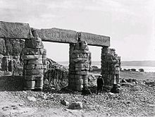
    The Great Zimbabwe city was built between the 12th and the 16th Century AD.

    It was a city with an economy based on trade, mainly Gold, ivory and livestock.

    It can still be viewed today from Google maps.
    Below is the link to the google map cordinates.

    https://maps.google.co.ke/maps?q=great+zimbabwe+history&ll=-20.272634,30.934963&spn=0.002843,0.005284&t=h&z=18

    https://maps.google.co.ke/maps?q=great+zimbabwe+history&ll=-20.272634,30.934963&spn=0.002843,0.005284&t=h&z=18

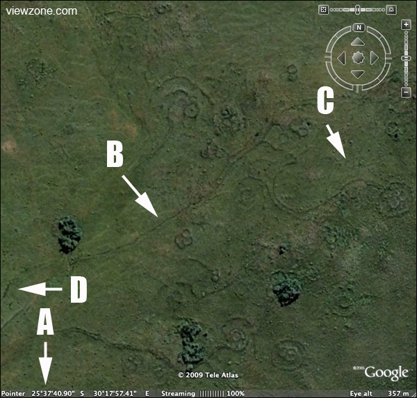
    From the aerial view, the planning was superb. There was the main building which was linked to several other buildings through well defined roads.

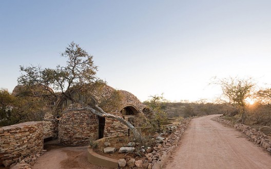
    The walls were curvilinear in shape and were constructed using stone.

    To shape stone as the Zimbabweans did, this means they had a good metal fabrication industry that could produce various chisels for this work.
    Also, to mine the gold and purify it, the Zimbabwean must have had very good metallurgy skills.
    Use of Gold as currency means that the early understanding of trade and economics was perfect.
    The current economic situation is abit on the lower side since till today, the US Dollar is still not backed by gold, hence has a value only on its paper worth based on what agreements have been made to represent value.

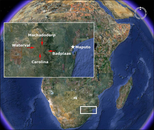
    Extension to South Africa.

    The link below is for a Google map of similar ancient cities near Swaziland with the same architecture as the Great Zimbabwe.

    Kingdom of Mapungubwe.1100 to 1300 AD.


    The Kingom of Mapungubwe, in South Africa, also constructed using stone on a similar architectural planning.

    http://en.wikipedia.org/wiki/Kingdom_of_Mapungubwe

    Here is the google map

    https://maps.google.co.ke/maps?q=kingdom+of+mapungubwe&ll=-22.213788,29.392891&spn=0.17958,0.338173&hnear=Mapungubwe&t=h&z=12


    https://maps.google.co.ke/maps?q=25+55’+53.28%22+S+%2F+30+16’+13.13%22+E&ll=-25.931963,30.270461&spn=0.002726,0.005284&t=h&z=18

    https://maps.google.co.ke/maps?q=25+55’+53.28%22+S+%2F+30+16’+13.13%22+E&ll=-25.931963,30.270461&spn=0.002726,0.005284&t=h&z=18

    This could mean that the Great Zimbabwe civilisation covered a very huge area, with Great Zimbabwe as its epicentre, with a radius of thousands of kilometers.

    Here are other remains of a similar city in Baadplus, South Africa.

    https://maps.google.co.ke/maps?q=25+47’+33.45%22+S+%2F+30+40’+38.76%22+E&ie=UTF8&ll=-25.792861,30.677621&spn=0.001364,0.002642&hnear=33,+Canc%C3%BAn,+Quintana+Roo,+Mexico&t=h&z=19

    https://maps.google.co.ke/maps?q=25+47’+33.45%22+S+%2F+30+40’+38.76%22+E&ie=UTF8&ll=-25.792861,30.677621&spn=0.001364,0.002642&hnear=33,+Canc%C3%BAn,+Quintana+Roo,+Mexico&t=h&z=19

    https://maps.google.co.ke/maps?q=25+38’+07.82%22+S+%2F+30+21’+18.79%22+E&ll=-25.635897,30.356426&spn=0.005465,0.010568&t=h&z=17

    https://maps.google.co.ke/maps?q=25+38’+07.82%22+S+%2F+30+21’+18.79%22+E&ll=-25.635897,30.356426&spn=0.005465,0.010568&t=h&z=17

    This city near Emgwenya, South Africa, has its interlinking roads in between the various smaller cities clearly visible on google maps.

    https://maps.google.co.ke/maps?q=25+39’+22.42%22+S+%2F+30+17’+03.25%22+E&ll=-25.656353,30.283991&spn=0.002732,0.005284&t=h&z=18

    https://maps.google.co.ke/maps?q=25+39’+22.42%22+S+%2F+30+17’+03.25%22+E&ll=-25.656353,30.283991&spn=0.002732,0.005284&t=h&z=18

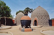
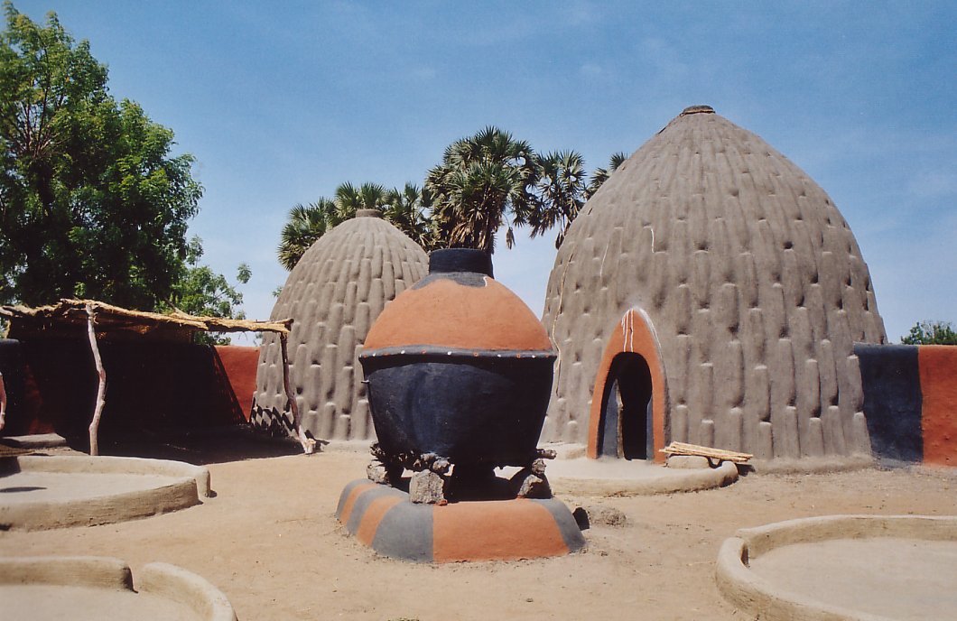
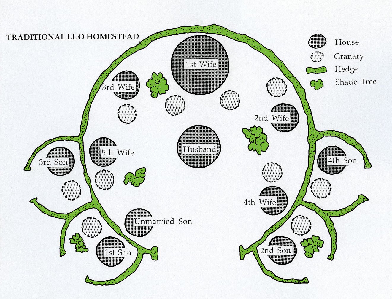
    Kenyan pre colonial villages.

    Most Kenyan pre colonial villages shared the same planning whereby the outer boundary was curvilinear and the buildings were circular in nature.
    The difference comes in use of materials in that adobe mud was used for walling while the Zimbabwe villages used stone for walling.

    Iron Age.

    In Africa, ancient Africans moved from using stone tools to iron directly without the copper and bronze stage. In other parts of the world, there was a gradual shift from stone age to copper,bronze then iron except in Africa. Copper and Bronze are easier to extract , purify and mould into shape, compared to iron, which is more complex.

    http://en.wikipedia.org/wiki/Iron_Age

    In Nigeria, iron smelting was already in place in the 6th century BC.
    http://en.wikipedia.org/wiki/Nok_culture

    The ability to make iron tools was then implemented in making farm tools used to clear forests , dig and plant crops . This was spread from Nigeria to the rest of Africa and the world through the migrating Bantu communities.

    Norhtern Tanzania , in particular, had very complex iron smelting furnaces that could produce high quality steel in the ancient times.
    http://link.springer.com/article/10.1007%2FBF01117455#page-1

    The Chifumbanze people are responsible for the rapid spread of iron smelting technology in Africa. They started from West Africa to South Africa and finally to East Africa. They had a liking for trade, farming and living in hilly areas. They are also responsible for construction of the Great Zimbabwe city.

    Use of iron tools to arm themselves from invaders also ensured the early African civilisations protected themselves from slave trade.

    Conclusion.

    Use of iron tools within the construction industry aided the ancient Bantu people to construct using stone. Variuos iron mongery such as door locks, door hinges etc were also incorprated into the building. Also, most doors were meticulously curved into interesting patterns using steel tools.
    Cities such as the Great Zimbabwe were constructed in the 12th century AD, just after discovery of steel in Africa. Bantu migration was also active after the steel discovery.

    http://www.hamillgallery.com/EXHIBITIONS/AfricanDoors.html

    Francis Gichuhi Kamau, Architect.
    info@architect.com